Google 站內搜尋
-
Lastest Posts
Category
- aerofoto (8)
- GE 3D (9)
- GE 4D (17)
- GE PHOTO (10)
- GE Plugin (3)
- GE 導航 (5)
- GE 應用 (36)
- GE 教學 (8)
- GE 旅遊 (23)
- GE 登山 (21)
- GE 飛覽 (26)
- GE創新應用 (9)
- GE地景模擬 (17)
- Google Earth Studio (1)
- Google Earth Tour (18)
- Google街景地圖 (26)
- MarziPano (1)
- New Google Earth (10)
- twFlyover (2)
- 台大校園 (28)
- 室內環景圖 (1)
- 市政應用 (8)
- 應用產生器 (24)
- 成大 (14)
- 我的社區 (1)
- 新聞事件 (3)
- 未分類 (6)
- 自製街景圖 (15)
- 街景導覽 (8)
- 越野跑 (7)
- 運動 (1)
Recent Comments
- 「read more」於〈如何在手機上製作Google Earth盤旋飛覽〉發佈留言
- 「地圖如何看實景? - 生日優惠網」於〈主題式Google街景圖播放網頁產出器〉發佈留言
- 「手機怎麼看街景圖? - 生日優惠網」於〈Google 特色景點街景 in Google Earth〉發佈留言
- 「TommyMut」於〈祝山日出〉發佈留言
- 「蜥蜴」於〈南沙太平島之旅〉發佈留言
標籤雲
Statistics

License
Feed On
-
Lastest Posts
Category
- aerofoto (8)
- GE 3D (9)
- GE 4D (17)
- GE PHOTO (10)
- GE Plugin (3)
- GE 導航 (5)
- GE 應用 (36)
- GE 教學 (8)
- GE 旅遊 (23)
- GE 登山 (21)
- GE 飛覽 (26)
- GE創新應用 (9)
- GE地景模擬 (17)
- Google Earth Studio (1)
- Google Earth Tour (18)
- Google街景地圖 (26)
- MarziPano (1)
- New Google Earth (10)
- twFlyover (2)
- 台大校園 (28)
- 室內環景圖 (1)
- 市政應用 (8)
- 應用產生器 (24)
- 成大 (14)
- 我的社區 (1)
- 新聞事件 (3)
- 未分類 (6)
- 自製街景圖 (15)
- 街景導覽 (8)
- 越野跑 (7)
- 運動 (1)
Recent Comments
- 「read more」於〈如何在手機上製作Google Earth盤旋飛覽〉發佈留言
- 「地圖如何看實景? - 生日優惠網」於〈主題式Google街景圖播放網頁產出器〉發佈留言
- 「手機怎麼看街景圖? - 生日優惠網」於〈Google 特色景點街景 in Google Earth〉發佈留言
- 「TommyMut」於〈祝山日出〉發佈留言
- 「蜥蜴」於〈南沙太平島之旅〉發佈留言
標籤雲
Statistics
License
Feed On
Category Archives: GE 登山
高山照片判釋 – 國家地理雜誌1969年高山積雪照片
這張照片是2013年9月至11月「國家地理雜誌125年經典影像展」的其中一張,成 … Continue reading
Posted in GE 登山, GE地景模擬, 成大
Leave a comment
高山照片判釋 – 日治時期原住民登次高山頂舊照
臺灣國定古蹟編纂研究小組(National Historic Monuments … Continue reading
北插天山山系飛覽
成大山協OB的103年六月份活動是美鹿山、高腰山、拔刀爾山,我看了活動說明,文中 … Continue reading
Posted in GE 登山, Google Earth Tour
Leave a comment
烘爐地山五路會師 Google Earth 地形導覽
由於Google Earth自2014年底已不再提供Google Earth P … Continue reading
Posted in GE 登山, Google Earth Tour, 成大
Leave a comment
MIT台灣誌 中央山脈大縱走
由於Google Earth 己不再支援 Google Earth Plugin … Continue reading
Posted in GE 登山, Google Earth Tour
Leave a comment
成大山協OB松蘿湖 Google Earth 記行
由於Google Earth自2014年底已不再提供Google Earth P … Continue reading
中央山脈百岳超廣角大縱走
由於Google Earth自2014年底已不再提供Google Earth P … Continue reading
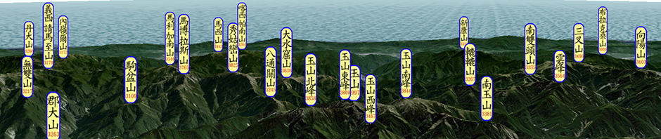
雪山飛覽
自從去年接觸到齊柏林的空照圖之後,就想搭乘(藉著)齊兄的空照圖來飛覽台灣的高山, … Continue reading
Posted in GE 登山, GE 飛覽, twFlyover
6 Comments
台北市北方屏障-陽明山國家公園群山飛覽
屈指算來,我在台北市也住了27個年頭,陽明山的各山頭也爬過不知多少回了,但對於每 … Continue reading

