Google 站內搜尋
-
Lastest Posts
Category
- aerofoto (8)
- GE 3D (9)
- GE 4D (17)
- GE PHOTO (10)
- GE Plugin (3)
- GE 導航 (5)
- GE 應用 (36)
- GE 教學 (8)
- GE 旅遊 (23)
- GE 登山 (21)
- GE 飛覽 (26)
- GE創新應用 (9)
- GE地景模擬 (17)
- Google Earth Studio (1)
- Google Earth Tour (18)
- Google街景地圖 (26)
- MarziPano (1)
- New Google Earth (10)
- twFlyover (2)
- 台大校園 (28)
- 室內環景圖 (1)
- 市政應用 (8)
- 應用產生器 (24)
- 成大 (14)
- 我的社區 (1)
- 新聞事件 (3)
- 未分類 (6)
- 自製街景圖 (15)
- 街景導覽 (8)
- 越野跑 (7)
- 運動 (1)
Recent Comments
- 「read more」於〈如何在手機上製作Google Earth盤旋飛覽〉發佈留言
- 「地圖如何看實景? - 生日優惠網」於〈主題式Google街景圖播放網頁產出器〉發佈留言
- 「手機怎麼看街景圖? - 生日優惠網」於〈Google 特色景點街景 in Google Earth〉發佈留言
- 「TommyMut」於〈祝山日出〉發佈留言
- 「蜥蜴」於〈南沙太平島之旅〉發佈留言
標籤雲
Statistics

License
Feed On
-
Lastest Posts
Category
- aerofoto (8)
- GE 3D (9)
- GE 4D (17)
- GE PHOTO (10)
- GE Plugin (3)
- GE 導航 (5)
- GE 應用 (36)
- GE 教學 (8)
- GE 旅遊 (23)
- GE 登山 (21)
- GE 飛覽 (26)
- GE創新應用 (9)
- GE地景模擬 (17)
- Google Earth Studio (1)
- Google Earth Tour (18)
- Google街景地圖 (26)
- MarziPano (1)
- New Google Earth (10)
- twFlyover (2)
- 台大校園 (28)
- 室內環景圖 (1)
- 市政應用 (8)
- 應用產生器 (24)
- 成大 (14)
- 我的社區 (1)
- 新聞事件 (3)
- 未分類 (6)
- 自製街景圖 (15)
- 街景導覽 (8)
- 越野跑 (7)
- 運動 (1)
Recent Comments
- 「read more」於〈如何在手機上製作Google Earth盤旋飛覽〉發佈留言
- 「地圖如何看實景? - 生日優惠網」於〈主題式Google街景圖播放網頁產出器〉發佈留言
- 「手機怎麼看街景圖? - 生日優惠網」於〈Google 特色景點街景 in Google Earth〉發佈留言
- 「TommyMut」於〈祝山日出〉發佈留言
- 「蜥蜴」於〈南沙太平島之旅〉發佈留言
標籤雲
Statistics
License
Feed On
Category Archives: GE 登山
如何製作3D軌跡圖
上圖是Petr Novotny在今年七月間以二天走了玉山群峰、八月時用三天走馬博 … Continue reading
Posted in GE 登山, 應用產生器
Leave a comment
台灣三千公尺以上山頭數量的探究
日前Petr Novotny問我有沒三千公尺以上山峰的Official list … Continue reading
Posted in GE 登山
Leave a comment
桃山神木探訪 Google Earth記行
我曾在2017年8月透過Google Earth的相片(PhotoOverlay … Continue reading
Posted in GE 登山, Google Earth Tour
Leave a comment
成大登山薪傳協會2019谷關七雄同步登頂Google Earth飛覽
成大登山薪傳協會於102年舉辦(宜蘭)烘爐地山五路會師,104年舉辦雪山四路會師 … Continue reading
Posted in GE 登山, GE創新應用, 成大
Leave a comment
K2 Project Google Earth Tour
台灣登山家張元植+呂忠翰挑戰攻頂K2高峰,他們6/14日(五)由台北出發,轉經北 … Continue reading
Posted in GE 登山, Google Earth Tour
Leave a comment
k2 Project 攀登路線 Google Earth 飛覽
最近重心都擺在Google街景圖的拍攝,前陣子在FB看到有個”k2 … Continue reading
Posted in GE 登山, GE 飛覽, Google Earth Tour
Leave a comment
成大登山薪傳協會 106年度李崠山會師 Google Earth 飛覽
成大登山薪傳協會106年度大戱是選定擁有一等三角點,為台灣小百岳之一的李崠山進行 … Continue reading
Posted in GE 登山, GE地景模擬, Google Earth Tour, 成大
Leave a comment
馬博拉斯橫斷+嘆息灣 Google Earth飛覽
成大登山薪傳協會OB每月登山活動,自民國97年12月開始,迄今已近九年未曾間斷, … Continue reading
Posted in GE 登山, Google Earth Tour, 成大
Leave a comment
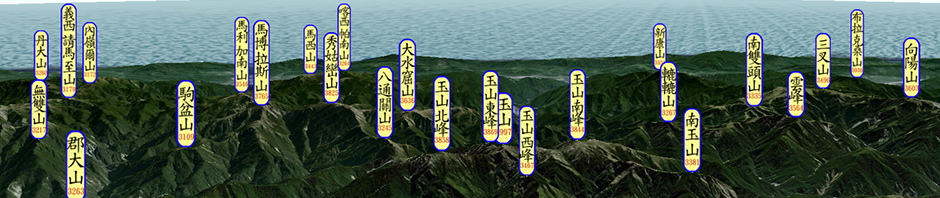
360° PanoTour + Mountain name in Google Earth
Google Earth有個PhotoOverlay(照片)功能,可以將一般照片 … Continue reading
Posted in GE 登山, GE地景模擬, 應用產生器
Leave a comment
雪山山脈稜脈展示與六路會師Google Earth飛覽
先分享個資訊給大家 – 成大學生社團回顧展(I) 履痕足跡──成大山 … Continue reading
Posted in GE 登山, GE創新應用, Google Earth Tour, 成大
Leave a comment

