Google 站內搜尋
-
Lastest Posts
Category
- aerofoto (8)
- GE 3D (9)
- GE 4D (17)
- GE PHOTO (10)
- GE Plugin (3)
- GE 導航 (5)
- GE 應用 (36)
- GE 教學 (8)
- GE 旅遊 (23)
- GE 登山 (21)
- GE 飛覽 (26)
- GE創新應用 (9)
- GE地景模擬 (13)
- Google Earth Studio (1)
- Google Earth Tour (18)
- Google街景地圖 (26)
- MarziPano (1)
- New Google Earth (10)
- twFlyover (2)
- 台大校園 (28)
- 室內環景圖 (1)
- 市政應用 (8)
- 應用產生器 (23)
- 成大 (14)
- 我的社區 (1)
- 新聞事件 (3)
- 未分類 (3)
- 自製街景圖 (15)
- 街景導覽 (8)
- 越野跑 (7)
- 運動 (1)
Recent Comments
- 「管先生」於〈點線面變形器〉發佈留言
- 「蜥蜴」於〈南沙太平島之旅〉發佈留言
- 「施博嶸」於〈舉世最高-紅杉巨木〉發佈留言
- 「How to make 3D Pie Chart in Google Earth | GEmVG Blog」於〈2008 中華民國第十二屆正副總統選舉〉發佈留言
- 「蜥蜴」於〈趣遊碗《松山文創園區魚眼鳥瞰圖》與Google Earth交鋒在台北〉發佈留言
標籤雲
Statistics

鏈結
License
Feed On
Search Results for: 百岳
百岳720環景地圖
Google 街景服務自2009年開始在台灣深耕後,服務網遍佈全台大街小巷,在高 … Continue reading
Posted in Google街景地圖, 自製街景圖
Leave a comment
百岳巡禮
自從使用Google Earth以來,隨著Google Earth的版本演化,台 … Continue reading
Posted in New Google Earth, 應用產生器
Leave a comment
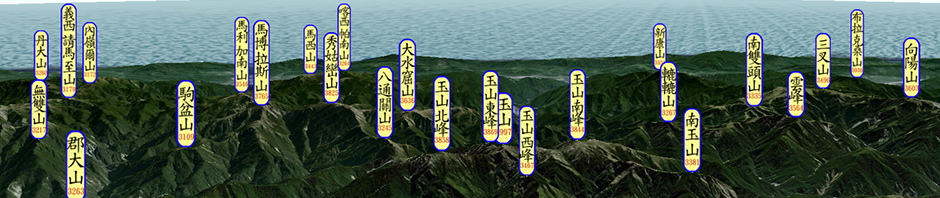
中央山脈百岳超廣角大縱走
由於Google Earth自2014年底已不再提供Google Earth P … Continue reading
【Google Earth飛覽】『赤心巔峰』- 九日越野挑戰中央山脈 全記錄
2022年10月9日,古明政(古塵流 、山頂狼) 與周青 (Chou-Ching … Continue reading
Posted in 越野跑
Leave a comment
如何製作3D軌跡圖
上圖是Petr Novotny在今年七月間以二天走了玉山群峰、八月時用三天走馬博 … Continue reading
Posted in GE 登山, 應用產生器
Leave a comment
台灣三千公尺以上山頭數量的探究
日前Petr Novotny問我有沒三千公尺以上山峰的Official list … Continue reading
Posted in GE 登山
Leave a comment
濁水溪流域360環景3D地圖
自去(2019)年8月間看了蔡日興的”丹‧巴羅博”之後, … Continue reading
Posted in GE地景模擬, 自製街景圖
Leave a comment
在手機上,如何活用Google Earth?
事情就從上面這張照片開始的,前幾天,我一早進辦公室,打開電腦,就看到了FB上有篇 … Continue reading
Posted in New Google Earth
Leave a comment
成大登山薪傳協會 106年度李崠山會師 Google Earth 飛覽
成大登山薪傳協會106年度大戱是選定擁有一等三角點,為台灣小百岳之一的李崠山進行 … Continue reading
Posted in GE 登山, GE地景模擬, Google Earth Tour, 成大
Leave a comment

